Lines that Divide: Redlining, Displacement, and Survival
By Erika Pietrzak and Kameron Raynor, March 11, 2026
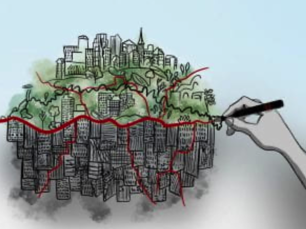
Redlining wrote injustice into the land, leaving Black communities boxed in with factories, smog, and sickness. Nearly a century later, from Tulsa Race Massacre to Cancer Alley, the fight for clean air and safe streets continues.
Source: Salon
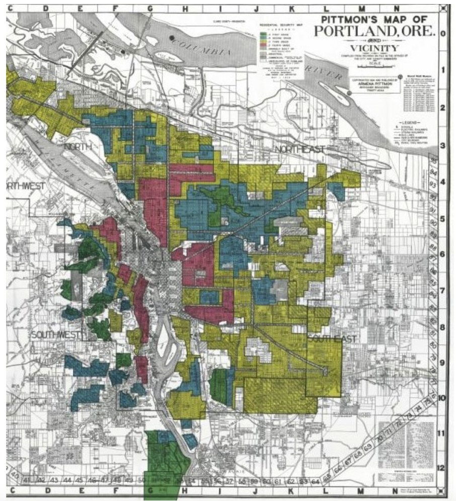
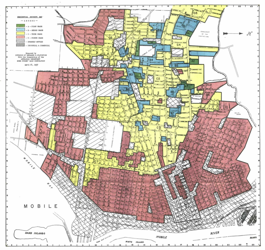
In the early 1900s, National Boards and Federal legislation systematically divided housing based on racial and ethnic lines, a process known as redlining. The Federal Housing Administration formalized the redlining process through the National Housing Act of 1934. Maps were changed to create different zones graded one (best) through four (worst), with grade fours marked “as too ‘hazardous’ … for federal home loans.” By withholding mortgage capital and attracting factories due to less oversight, minorities were isolated in inner-city neighborhoods that were legally segregated over time. These neighborhoods were denied access to the same resources, funds, and government attention. This led to a devaluation of those neighborhoods, created public health issues, brewed environmental justice problems, and exacerbated existing inequalities.
“Redlining steals health and wealth. It was bad for America in the 1920s, and its continuing effects are harmful in the 2020s today.” - Robert D. Bullard
The environmental impact of redlining fell hardest on Black communities. By segregating and neglecting these neighborhoods, the United States government created "undesirable" living areas and then made them worse by industrializing them, contaminating the air, water, and land. Redlined areas have fewer trees and more heat-trapping infrastructure, increasing the likelihood of extreme weather events while leaving residents with little protection against them. Altogether, this is a perfect recipe for disaster; it creates significant disparate health outcomes, reduces wildlife, and pollutes all surrounding ecosystems for Black communities across America.
Since redlining began, oil and gas companies specifically shifted their location decisions away from material sources and toward social factors, namely race. By heavily industrializing these neighborhoods, selling land to polluting corporations, and destroying green spaces, the American government simultaneously dismantled many thriving Black towns and forced Black Americans into shells of their former selves. Smoky air and putrid smells linger in the air while murky water contaminated by a long list of pollutants and chemicals uproots ecosystems and ways of life for Black communities. This environmental degradation lowered property values, making it nearly impossible for Black families and individuals to sell their homes, forcing generations to remain in unhealthy areas by the same system that confined them there. As a result, cancers, low birth weights, organ failure, and chronic illnesses plague these Black communities while their natural ecosystems were stripped, leaving little to no wildlife.
Source: Brown University
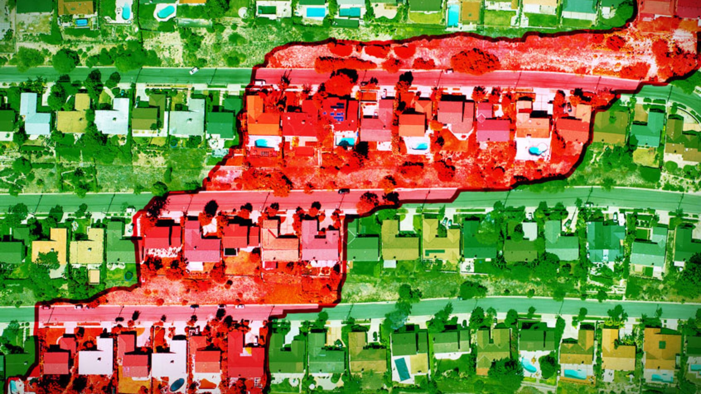
Tulsa, Oklahoma once boasted one of the most thriving Black communities in the country, known as Black Wall Street. However, the city was burned to the ground during the Tulsa Race Massacre, which lasted from May 31st to June 1st, 1921. White residents blatantly attacked the town of Tulsa, known as Greenwood or “Black Wall Street”, by going after businesses, homes, and residents. Racial tensions in Tulsa boiled over in the 1920s, resulting in Black Wall Street being looted and burned to the ground with a death toll in the hundreds. After the Tulsa Race Massacre, redlining quickly began, which separated Northern Tulsa and created lasting environmental injustices, placing Black and minority neighborhoods at higher risk for pollution and health disparities and creating lasting environmental injustices. Industry swooped in to take over the Black community and expose them to oil/gas drilling, resulting in elevated rates of asthma, cancer, and heat-related illness. These health impacts have contributed to the eleven-year life expectancy difference between North and South Tulsa. All these factors have also contributed to creating an "undesirable" area in Northern Tulsa with a population growth of fewer than 100,000 new citizens since 1970, while Oklahoma City has seen an increase of over 300,000. Industry also created a heat bubble around Tulsa with average temperatures “expected to rise five degrees Fahrenheit, and there could be up to 30 more days per year with temperatures over 100 degrees” without a drastic decrease in emissions. The Southern Climate Impacts Planning Program conducted a study on Tulsa’s environmental racism that found that the map of overall climate vulnerability closely aligns with the original redlining map of the city.
Source: Zinn Education Project
However, these are not just the stories of our grandparents. These environmental justice atrocities continue in many Black neighborhoods today, many of which are in the southeastern United States. One of the most well-known examples is Cancer Alley. Aptly named, this corridor from Baton Rouge to New Orleans, Louisiana, is an 85-mile stretch known for high concentrations of over 200 petrochemical plants that create toxic air emissions tied to the area’s particularly high cancer rates in 40 percent Black neighborhoods. Much of this land was plantation land before being redlined to create a stretch in Louisiana that makes Black Louisianans seven to twenty-one times more exposed to industrial pollutants than their white counterparts. Pipelines have uprooted ecosystems and natural land in the area, while chemical plants today contaminate the rest of the once fertile soil. The stretch is also home to almost 200 other industrial facilities that emit toxic chemicals, such as benzene, formaldehyde, and ethylene oxide. Smoke billows from plants next door to family homes, noxious smells fill the air, and respiratory ailments riddle entire neighborhoods. Even in 2023, racist zoning across Cancer Alley prompted a federal appeals court case. This has not changed realities in Cancer Alley; however, as in 2024, Formosa Plastics’ air permits were upheld, despite having to pay a $50 million settlement for “illegally dumping billions of plastic pellets and other pollutants in Texas waterways.” This grants them permission to build a petrochemical plant that could release up to 800 million tons of toxic air pollutants annually.
In Africatown, Alabama, a long and dark history that started with slavery and Clotilda, the arrival of the last known US slave ship, continues with toxic pollution that permeates the town. Long after slavery had been banned, the Clotilda made the last known illicit trip with 100 captured slaves who traveled in the cargo hold naked to the Americas. Once sold in America, this area in Southern Alabama was plagued with Jim Crow laws, redlining, and discrimination for generations. During the 20th and 21st centuries, Africatown has not only been subject to poverty but also to environmental injustice. Almost all of the Mobile, Alabama area was labeled as grade three or four zones during redlining, including Africatown. In the 1970s, thousands of residents were displaced to build factories like the Scott Paper Company and the International Paper Company, which eventually split the town in half. Left behind by redlining and the government, sanitation has become a serious health crisis in Africatown as generations have gone without basic sanitation services, and raw, untreated sewage has infected children’s spaces. As of 2024, Africatown is enveloped by the “chemical corridor,” a 60-mile stretch of land that is home to over 300 factories and other sources of pollution that casts a literal shadow across the region, with Africatown suffering the brunt of it.” Of Mobile County’s 47 pollution-producing industries, 30 of those are located within three miles of Africatown, forcing many residents to constantly wear masks when outside. Diesel Particulate Matter Level (DPML) in the air and proximity to superfund sites are highest in Africatown of the surrounding Mobile area. DPML is carcinogenic to humans, causing lung cancer, asthma, and more. Today, the percentage of houses in Africatown with lead paint is more than three times higher than the state average. Africatown also has the worst air quality in the state of Alabama, as of 2022, with exposure to airborne respiratory hazards in the 95th to 100th percentile.
Source: University of South Alabama
Even within the same city or county, the racial disparities create environmental injustices on the local scale that can be just as damaging to its residents. In Denver, “smokestacks, freeway traffic, and clanging railyards that other parts of Denver can ignore” riddle the neighborhoods that redlining created. Central, Northern, and South Western Denver were labeled grade four and thus packed with ethnic communities and neglected. As a result, DPML, toxicity-weighted stream concentrations, and particulate matter levels are all higher in the grade four districts. These communities are also closer to Superfund sites and hazardous-waste management facilities. They also possess less tree canopy coverage, which results in higher monthly maximum and average temperatures within these communities. In fact, there is about a 12-degree Fahrenheit difference between well-rated and poorly rated redlined neighborhoods today. The University of Colorado Boulder found that redlining is linked to current disproportionate air pollution in Denver. In Northern Denver, multiple high-profile energy facilities, such as the Cherokee Generating Station and Suncor Oil Refinery, pollute nearby air and waters while repeatedly violating EPA standards. There have been 183 facilities with recorded violations in Denver from 2021 to 2024, with more than half of these facilities located in Northern Denver. The Nestle-Purina pet food factory is one of the many harmful factories in Northern Denver, emitting “noxious odors and has been out of compliance with the Clean Water Act for the past three years” as of 2024. Traintracks, highways, and railyards in Denver are also much denser in redlined areas, contributing to more diesel and car pollution in Northern Denver, particularly.
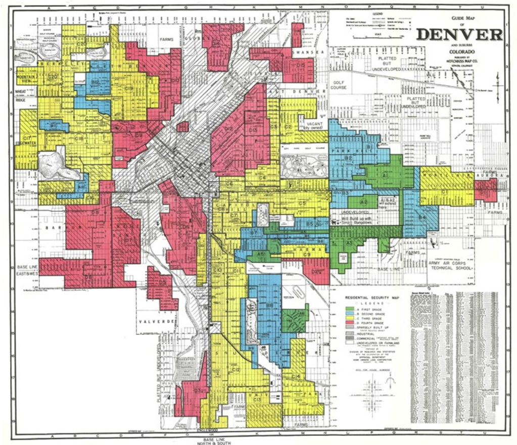
Source: 9News
Baltimore, Maryland, is a similar case. Divided by the government in the 1930s, generational scars remain today. Central Baltimore was labeled a grade four area, while Southern Baltimore was almost entirely a grade three area, both of which continue to feel the scars of the factories and industries polluting the communities for decades. Southern Baltimore “suffocates under the weight of air contamination caused by the high density of incinerators, coal terminals, and chemical plants in the area.” The Curtis Bay neighborhood is plagued by 70 stationary polluting facilities, contributing to some of the highest asthma and cancer rates in the country. (Bally, 2025, 1). The Curtis Bay section of Central Baltimore also deals with way too much pollution and environmental racism due to the coal industry. DPML is highest in Central Baltimore, as is the number of hazardous waste sites per kilometer. Southern Baltimore experiences closer proximity to superfund sites and higher levels of particulate matter in the air. The monthly maximum temperature and mean temperature are higher in Central Baltimore than anywhere else in Baltimore. South Baltimore has “some of the highest rates of asthma, cancer, and poverty rates in the country.” People in South Baltimore are more than twice as likely to die from asthma than the national rate. The percent of tree canopy coverage is low overall in Baltimore, but is almost non-existent in Central Baltimore. The University of Maryland found that “previously redlined neighborhoods had consistently lower street tree diversity and were much less likely to have larger, older trees on a site.” Redlining also contributed to the sewage issues present in the city today, with backups, sewage leakages, and failures more common in historically redlined neighborhoods. These sewage failures present a serious public health and environmental health hazard as E. Coli can poison the waters and animals.
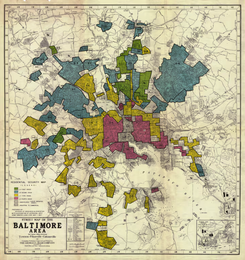
Source: The Washington Post
Los Angeles bears a similar reality that stretches across the country. Much of East and South LA were labeled group three or four sites during readlining, with most group four sites concentrated in East LA. The map of DPML levels in the area almost directly mirrors the redlining map from almost a century ago, as does the map of proximity to hazardous waste sites. Particulate Matter in the air is also densely present in East and South LA. Los Angeles is also home to one of the most important oil basins in the Western United States. These wells are found disproportionately in Black neighborhoods, and Southern LA has been contaminated by oil leaks since the 1920s, maintained by the oil industry ever since. Not only does oil take over Southeastern LA, but many industries set up home there, polluting and contaminating surrounding neighborhoods. Rendering companies that deal with expired meat and dead animals create putrid odors, many of which regularly violate air quality regulations. Baker Commodities LLC, for example, was temporarily shut down in 2022 after violating a rule “meant to keep odors from seeping into surrounding neighborhoods” and reopened in June of the next year. Exide Technologies exposed Black communities to brain-damaging lead for decades before its eventual closing. Petroleum waste from an old city dump causes bubbling at a school in Southeastern LA. Altogether, many public health concerns plague the area, while local ecosystems are almost wiped out.
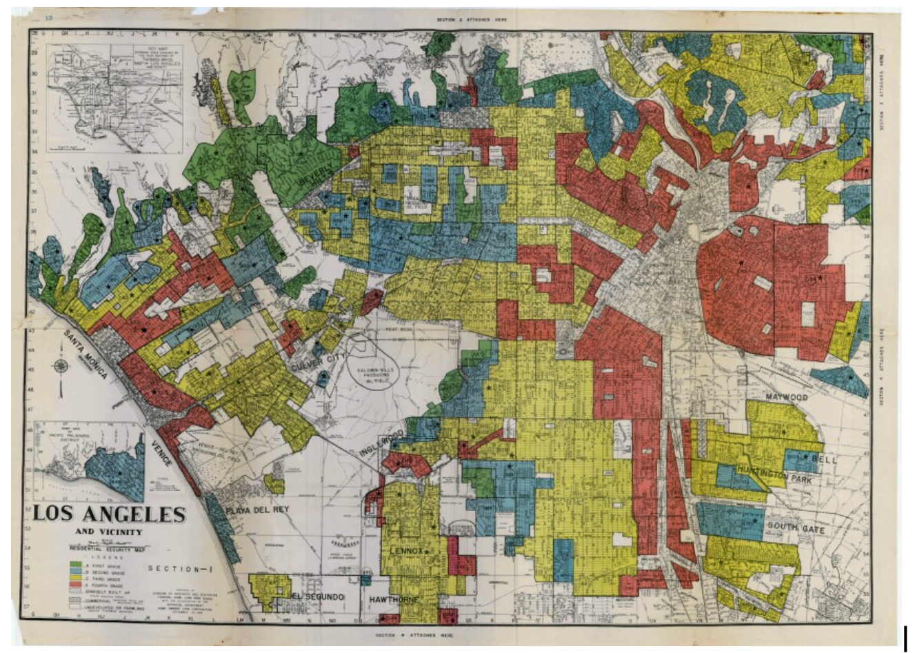
Source: PBS SoCal
Redlining changed America almost a century ago, yet its impact is still felt generations later. Black Americans are 75 percent more likely to live next to polluting sites than white Americans, with much of this disparity attributed to redlining. More than one million Black Americans “are exposed to the invisible forms of pollution from oil drilling, including noise, air, and water pollution.” Redlined neighborhoods also experience hotter temperatures and increased health risks. By industrializing, reducing natural spaces, turning a blind eye to illegal contaminants, and concentrating pollution industries in group four neighborhoods, Black neighborhoods were legally segregated and trapped families in their homes, then environmentally degraded over time into the public health crises across the country today. The lines drawn on those maps may be gone, but their consequences are still being lived with.
Change the Chamber is a nonpartisan coalition of young adults, 100+ student groups across the country, environmental justice and frontline community groups, and other allied organizations. To support our work, donate or join our efforts!